
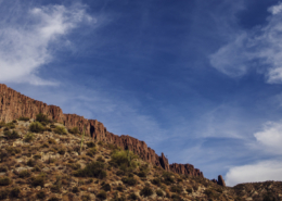
Land Exchange
The Resolution Copper land exchange was completed on March 16, 2026. This is a key step in developing a safe, modern mining operation.
Through the Southeast Arizona Land Exchange and Conservation Act, the federal government and the public received more than 5,400 acres of high-value conservation land, including riparian habitat, wildlife corridors, and culturally significant landscapes. These lands will be permanently protected and managed for public benefit.
In return, Resolution Copper received approximately 2,400 acres adjacent to the historic Magma Copper mine to enable exploration and development of the Resolution Copper deposit.
Over more than a decade, input from a wide range of stakeholders including the Town of Superior, nearby Native American Tribes, the U.S. Forest Service, the Bureau of Land Management, Audubon, and The Nature Conservancy helped shape the land exchange process. These voices guided the selection of parcels that would provide the greatest public benefit. Take a closer look at each land parcel the public received as part of the land exchange.
Maintaining public access to Oak Flat Campground
Mining and public use have coexisted in the Oak Flat area for decades. As part of the land exchange, Resolution Copper is committed to keeping Oak Flat Campground open and accessible to the public, including local communities and Native American Tribes.
Visitors can expect the same experience they’ve always enjoyed, with no noticeable changes from the previous Tonto National Forest practices for decades to come. To ensure continued access and on-the-ground stewardship, the Oak Flat campground will be managed by 4Winds Contracting, a company owned by a San Carlos Apache Tribe member, which will oversee campground maintenance, facilities, and road access. Learn more >
For more information on the Oak Flat Campground, please visit azoakflat.com.
Resources
 https://resolutioncopper.com/wp-content/uploads/2026/07/rio_tinto_AZ_july2022-69d-2-scaled-e1785299266574.jpg
1024
2560
admin1
https://resolutioncopper.com/wp-content/uploads/2021/09/resolution-copper-logo-white.png
admin12026-07-29 19:00:002026-07-29 04:31:28Resolution Copper Establishes $54 Million Tribal Trust
https://resolutioncopper.com/wp-content/uploads/2026/07/rio_tinto_AZ_july2022-69d-2-scaled-e1785299266574.jpg
1024
2560
admin1
https://resolutioncopper.com/wp-content/uploads/2021/09/resolution-copper-logo-white.png
admin12026-07-29 19:00:002026-07-29 04:31:28Resolution Copper Establishes $54 Million Tribal Trust https://resolutioncopper.com/wp-content/uploads/2026/07/Q2-Scorecard_Blog-Post-Image.png
600
1200
admin1
https://resolutioncopper.com/wp-content/uploads/2021/09/resolution-copper-logo-white.png
admin12026-07-29 00:34:372026-07-29 00:34:39Q2 2026 Scorecard: Looking at the Numbers Behind Our Work
https://resolutioncopper.com/wp-content/uploads/2026/07/Q2-Scorecard_Blog-Post-Image.png
600
1200
admin1
https://resolutioncopper.com/wp-content/uploads/2021/09/resolution-copper-logo-white.png
admin12026-07-29 00:34:372026-07-29 00:34:39Q2 2026 Scorecard: Looking at the Numbers Behind Our Work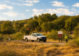 https://resolutioncopper.com/wp-content/uploads/2026/07/RC-Oak-Flat-Campground-Stewardship-Update_July2026-3.png
1024
1536
Troy Corder
https://resolutioncopper.com/wp-content/uploads/2021/09/resolution-copper-logo-white.png
Troy Corder2026-07-23 16:39:462026-07-23 16:39:47Stewardship You Can See at Oak Flat Campground
https://resolutioncopper.com/wp-content/uploads/2026/07/RC-Oak-Flat-Campground-Stewardship-Update_July2026-3.png
1024
1536
Troy Corder
https://resolutioncopper.com/wp-content/uploads/2021/09/resolution-copper-logo-white.png
Troy Corder2026-07-23 16:39:462026-07-23 16:39:47Stewardship You Can See at Oak Flat Campground https://resolutioncopper.com/wp-content/uploads/2026/07/RC-Scholarships-Awarded-2026_Superior-High-School-2_1200x1200.png
1254
1254
Troy Corder
https://resolutioncopper.com/wp-content/uploads/2021/09/resolution-copper-logo-white.png
Troy Corder2026-07-17 04:19:222026-07-17 04:24:34Resolution Copper Awards $51,000 in Scholarships to 20 Local Students
https://resolutioncopper.com/wp-content/uploads/2026/07/RC-Scholarships-Awarded-2026_Superior-High-School-2_1200x1200.png
1254
1254
Troy Corder
https://resolutioncopper.com/wp-content/uploads/2021/09/resolution-copper-logo-white.png
Troy Corder2026-07-17 04:19:222026-07-17 04:24:34Resolution Copper Awards $51,000 in Scholarships to 20 Local Students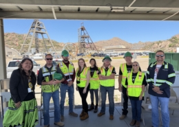 https://resolutioncopper.com/wp-content/uploads/2026/07/Tour-with-Apache-Junction-Residents-and-LD7-Candidate-scaled.jpg
1920
2560
Troy Corder
https://resolutioncopper.com/wp-content/uploads/2021/09/resolution-copper-logo-white.png
Troy Corder2026-07-14 15:40:292026-07-14 15:40:32Resolution Copper in the Community | June 2026 Recap
https://resolutioncopper.com/wp-content/uploads/2026/07/Tour-with-Apache-Junction-Residents-and-LD7-Candidate-scaled.jpg
1920
2560
Troy Corder
https://resolutioncopper.com/wp-content/uploads/2021/09/resolution-copper-logo-white.png
Troy Corder2026-07-14 15:40:292026-07-14 15:40:32Resolution Copper in the Community | June 2026 Recap https://resolutioncopper.com/wp-content/uploads/2026/07/2026-Globe-Resolution-Business-of-the-Year-Award-2-e1783550080952.jpg
940
1936
Troy Corder
https://resolutioncopper.com/wp-content/uploads/2021/09/resolution-copper-logo-white.png
Troy Corder2026-07-08 22:35:242026-07-08 22:36:00Resolution Copper Named Large Business of the Year by Mesa and Globe-Miami Chambers of Commerce
https://resolutioncopper.com/wp-content/uploads/2026/07/2026-Globe-Resolution-Business-of-the-Year-Award-2-e1783550080952.jpg
940
1936
Troy Corder
https://resolutioncopper.com/wp-content/uploads/2021/09/resolution-copper-logo-white.png
Troy Corder2026-07-08 22:35:242026-07-08 22:36:00Resolution Copper Named Large Business of the Year by Mesa and Globe-Miami Chambers of Commerce https://resolutioncopper.com/wp-content/uploads/2026/07/RC-Employee-Welder-Bethany_Blog-Post-Image-2.png
941
1672
Troy Corder
https://resolutioncopper.com/wp-content/uploads/2021/09/resolution-copper-logo-white.png
Troy Corder2026-07-01 17:24:342026-07-01 21:02:36Resolution Copper and United Association Local 469 Enter into Master Supply Agreement Supporting Operations in Arizona
https://resolutioncopper.com/wp-content/uploads/2026/07/RC-Employee-Welder-Bethany_Blog-Post-Image-2.png
941
1672
Troy Corder
https://resolutioncopper.com/wp-content/uploads/2021/09/resolution-copper-logo-white.png
Troy Corder2026-07-01 17:24:342026-07-01 21:02:36Resolution Copper and United Association Local 469 Enter into Master Supply Agreement Supporting Operations in Arizona https://resolutioncopper.com/wp-content/uploads/2025/02/RC-AZ-and-Copper-Website-Header-Image.png
788
1875
admin1
https://resolutioncopper.com/wp-content/uploads/2021/09/resolution-copper-logo-white.png
admin12026-06-12 00:09:332026-06-12 00:09:35Opinion: Copper mine is a critical investment in Arizona
https://resolutioncopper.com/wp-content/uploads/2025/02/RC-AZ-and-Copper-Website-Header-Image.png
788
1875
admin1
https://resolutioncopper.com/wp-content/uploads/2021/09/resolution-copper-logo-white.png
admin12026-06-12 00:09:332026-06-12 00:09:35Opinion: Copper mine is a critical investment in Arizona https://resolutioncopper.com/wp-content/uploads/2026/06/image-20240228-174432-3afc9a1b-scaled.jpeg
1920
2560
admin1
https://resolutioncopper.com/wp-content/uploads/2021/09/resolution-copper-logo-white.png
admin12026-06-08 16:24:592026-06-08 16:25:57How Environmental Stewardship is Shaping the Future of Responsible Mining
https://resolutioncopper.com/wp-content/uploads/2026/06/image-20240228-174432-3afc9a1b-scaled.jpeg
1920
2560
admin1
https://resolutioncopper.com/wp-content/uploads/2021/09/resolution-copper-logo-white.png
admin12026-06-08 16:24:592026-06-08 16:25:57How Environmental Stewardship is Shaping the Future of Responsible Mining